Individual Hikes 2
Individual in the Pyrenees, One day hikes 2
General
All hikes can be done without a guide, unless mentioned otherwise.
Always check the weather forecast. Some of the hikes can not be done with fog.
All the hikes suggested, are previously hiked by the Bergtoppers, to exclude any surprises!
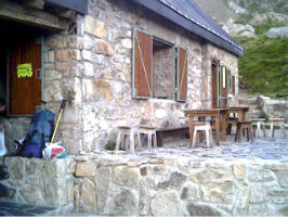
Hike from the river Riberot to the cabin of the ‘Bergtoppers’
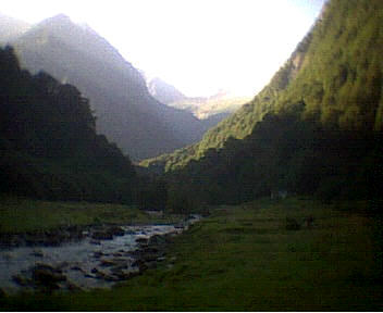
 The start of this hike is the Riberot, the river that comes from the Mont Valier reservate, a beautiful spot with a superb view…
You walk via the GR10 in the direction of the Cap and start right away with a steep climb. After a while you pass a cabin that can be used as a shelter.
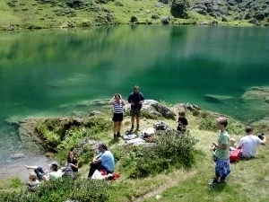
After the climb the track gets easier and while passing cows, sheep and horses you will reach a lovely lake where you can have lunch. I even saw people once swimming in the lake… (brrr)
It is another 3 hours walk to the Bergtoppers.
Depending of the time of year you could run into Isard (Spring) or raspberries (Autumn).
Remarks
Bring your lunch.
Start at the river Riberot and finish at the Bergtoppers.
Approximately 7 hours walk, 1.000 meters difference in altitude.
Hike is suitable for everyone.
Hike from the Col de la Core (1395 meters) to Etang d’Ayes (1860 meters) and back to the Col de la Core
 Today you start your hike at the col de la core. This col is done several times in the Tour de France.
From the Col you go up for 100 meters which is pretty heavy. After this climb it becomes easier and after a while you find lots of framboses. When you go out of the trees you climb a little more and on your right hand you will see Etang de Bethmale.
After this point of view you will reach another col very soon. Here you also find a cabin where you could spend the night.
After this col you will reach etang dÁyes in less then 30 minutes.
This lake is one of the most beautiful lakes in the Pyrenees.
After your picnic and your swim you walk back to the col de la core.
Remarks
Bring your lunch.
Start and finish at the Col de la Core.
Approximately 6 hours hike, 900 meters difference in altitude.
Suitable for everyone in a good shape.
From the Parking at Pucelle to the Riberot
 From the parking you start your hike with the Tour de Biros and after a while you find the GR10 in a beautiful valley. Here you start climbing first through the woods and later when you have passed the tree line you will see a nice cabin. This cabin is used often by hikers to spend the night. After a few 100 meters (up) you come at the Col de la Serre du Cot.
From here you go down via the GR10. The last part is pretty steap, but finally you reach a very nice place at the river the Riberot.
Remarks
Bring your picnic
Start Pucelle end auberge Mont Valier
Approximately 5 hours hike, 900 meters difference in altitude.
Suitable for everyone in good shape.
Hike from the Riberot (900 meters) to Estagnous (2245 meters)
 You drive to the Riberot, if you are not there yet, where you start your hike to the warded refuge Estagnous. After an hour and 30 minutes you reach a very nice cascade, a good place for your first brake.
From here you climb further a little steeper. Now you start sweating.
After an hour climbing you reach un anwarded cabin. A very nice place to have lunch. From here you can also see the refuge Estagnous.
Now it is another hour climbing.
Fortunately you can drink a very big beer or something else and have a hot shower………….
Remarks
Bring your lunch
Start Riberot, end Estagnous
Approximately 4 hours hike, 1.300 meters difference in altitude.
Suitable for everyone in good shape or people that are walking for 2 or more days.
Hike from Eylie (920) to refuge etang d’Araing (1965)
Today is the first day of the Individual Passaran.
After breakfast at the auberge you drive to Eylie d’en Haut by car.
Here you can park the car at the parking lot of the gite or elsewhere in Eylie.
The first part of the route you follow the yellow markings.
After climbing for a while you come out of the Col de Cos which is a good place to have lunch. There is water nearby and you can take shelter if necessary.
After lunch you descend a bit where you have a beautiful view of the Chapelle de l’Isard. Then you climb again to a cabin.
Now the last climb of 400 meters follows and as always the last stretch is the hardest. First you come to a large dam and eventually you come to the refuge with a nice view of the lake.
Remarks
Bring your packed meal
Start gite Eylie end refuge d’araing
Ca. 4-6 hours hiking, 1100 meters difference in altitude.
Suitable for everyone in good shape
Climbing the Pic de Crabere
After breakfast in the refuge you have the opportunity to climb the Pic.
It is a climb of about 700 meters that is doable without a backpack.
The Pic is located against the Spanish border at 2629 meters and offers a magnificent view.
When you are rested you take the same route back and you arrive at the refuge again.
Here you can have a coffee or perhaps something to eat.
Hike from refuge etang d’Araing (1950) to Eylie (990)
From the refuge you first go down a bit along the reservoir. On the other side of the lake is a spacious 2-storey cabin.
mining at Eylie
From here you will climb again to the Serre d’Araing (2221 meters). You will see a lot of remains of wood transports here.
From this point you will descend again. You pass the mining buildings that are no longer in use. This is an ideal place for a delicious lunch. There is also water here.
From here it is a bit of a descent before you reach the gite. You will spend the night in the gite on a half board basis. This is an easy day, actually a kind of rest day unless you have climbed the Pic de Crabere first.
Hike from Eylie (990) to the Riberot (925)
From gite Eylie to auberge la maison du Valier
Today there are 3 options
* walk from the gite to the auberge
* by car to Pucelle and a walk to the auberge
* rest day and by car to the auberge
Below is a description of the first choice. If you choose 2, you start walking halfway through the walk of choice 1.
You start with a fairly steep climb to the first ridge. Then you go a bit through the forest. After a few hours of climbing you arrive at the col de l’arech (1802 meters). The last climb is over grass.
You continue the GR10 by walking towards a cabin. This cabin is privately owned and unfortunately closed. You regularly encounter this when walking on the GR10, many private cabins that are closed.
After the col you go down again. During the descent there are plenty of places where you can find water. After about 5 hours of walking you will reach a river where you can have lunch. You are now at about 1010 meters. The first part for today is done.
After lunch I go on the road again. The GR10 immediately starts to climb steeply, but luckily the road is well marked. After about 2.5 hours of climbing you reach the highest point (1821 meters) of the second part of the day. At the top is a cabin for the shepherd. Here you can take a break again. Then you start the last descent of the day. Fortunately, the descent is easy to do and after a few hours of descending you reach the river Riberot.
This is the end point of this day. It is still a very beautiful place, no matter how often I visit. A glass of wine and the beautiful view quickly pushes the fatigue into the background.
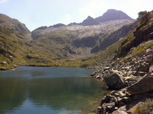
Hike from the Riberot (900) to refuge Estagnous (2245)

Group at Estagnous
Today is already the fourth walking day of the Individual Passaran.
After breakfast you will make your way to the waterfall. Today you follow a GR Transfrontalier and after an hour you arrive at a source. After this it is another half hour walk to the waterfall, a place where many people go for day trips. Ideal for lunch…
After lunch you go up again what looks like walking a bit of stairs. Very soon the bridge at the waterfall is just a small bridge. After more than an hour you arrive at an unmanned cabin, from where you can already see the mountain hut. It is located exactly under the saddle of Mont Valier and directly above the marking sign.
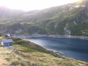
From the cabin you still have about 400 meters to go. First you will see the Etang Rond appear on the right. After climbing for a while you see the Etang long and on the left you see refuge Estagnous looming. It’s not far now.
Laurent and Stephan are the cabin values of this refuge. You can take a warm shower, or take a dip in one of the small lakes (Estagnous). You could also choose to have a drink first.
Remarks
Bring your packed meal
Start Riberot, end Estagnous
Ca. 4 hours hiking, 1300 meters going up
Suitable for everyone in good shape
Hike from refuge Estagnous (2245) to the Riberot (925)
Etang Milouga
After the French breakfast you start again with a steep climb to Col de Pecouch. Part of the route you walk today is included in the freedom route, or the Chemin de la Liberte. This route was walked a lot in the 2nd world war by, among others, Jews to flee to Spain. After all, it was easier to get to England from Spain (sometimes via Portugal). Then you descend over a rock slab until you reach a nice lake. You can also swim here in warm weather…
You continue the route and pass a nice cabin. After about 3 hours you reach Cap de Lauzes, where we connect to the GR10. After 900 meters of descending you arrive at the Riberot where you will sleep well with Laurent and Isabelle.
Remarks
Bring your packed meal
Start Estagnous end Riberot
Ca. 7 hours hiking, 200 meters up and 1400 meters down
Suitable for everybody with a good shape
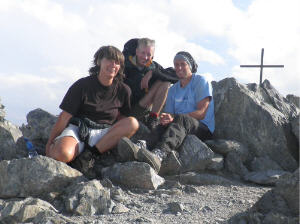
2838 meter, top Mont Valier
Climbing of the Mont Valier (2838 meters)
Today you can climb the Mont Valier!
From the cabin of Estagnous it is about 1 hour to the saddle.
From here it is about 30 minutes to go to the top.
If the weather is good you have a splendid view of the Couserans.
Now you are at the highest point of the
Haut Couserans: 2838 meters!
Remarks
Bring your lunch.
Start and finish: refuge Estagnous.
Approximately 4 hours hike, 600 meters difference in altitude.
Suitable for everyone.
Hike from the Col de la Core to the river of the Riberot
From the Col de la Core you go up for the Col d’Auedole via a nice, rough path. probably you will see lots of raspberries and some isards.
After a 1 ½ hours walk you reach a cabin, a shelter for maximum 5 people.
From here it is only 20 minutes to go a lake with a beautiful view: Etang d’Ayes.A beautiful place to have a break. You can even have a swim at the lake… After another hours walk, you will reach another cabin. Here you find a sign for the valley of the Riberot and you start the descend to the river Riberot.
A beautliful spot to sit at the river and view Mont Valier.
You could extend the walk for another hour to a beautiful cascade.
Remarks
Bring your lunch.
Start at the Col de la Core and finish at the Riberot.
Approximately 6 hours hike, 900 meters difference in atitude.
Suitable for everyone.
The hike can be extended.