GR10 Description in the Pyrenees
The Oriental Pyrenees from Merens to Banyuls in 2018
The French Pyrenees are about 900 km and consist of the Atlantic Pyrenees, the Pyrenees Centrales, the Ariege and the Pyrenees Orientales.
The Atlantic Pyrenees consist of the Pays Basque and the Bearn. The GR10 part here is about 260 kilometers and starts in Hendaye and ends in Arrens.
The GR10 part what goes through the Pyrenees Centrales (Hautes Pyrenees and Haut Garonne) starts in Arrens and ends in Fos. This part is about 220 kilometers.
The Ariege consists of the Bergtoppers domain and the GR10 starts in Fos and ends in Merens Les Vals. This part is about 225 kilometers.
The last part, the Oriental Pyrenees ends towards the Mediterranean and that GR10 part is about 210 kilometers. You start in Merens les Vals and you end in Banyuls sur Mer.
Since 2007 we offer the whole year backup from Melles until Goulier. You must think of luggage transport combined with the reservation of your accommodations. We also offer the whole year (from june till october) 2 self lead GR10 stretches: from Melles to Seix and from Seix to Goulier.
We also offer luggage transport, reservation of your accommodation, deliver maps and a detailed description and we can take care for your lunches.
And we walk the part from Luchon to Merens every year to check if something changed (cabins open/closed, difficulties etc.)
From here a description of the GR10 stretches that I have done. I started at Hendaye and ended in Arrens. Of course any one can use the description but you can also contact Bergtoppers.
The Oriental Pyrenees from Merens to Banyuls
This is walked in 2005
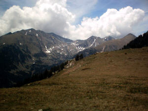
From Merens les Vals (1050 meters) to Refuge des Besines (1981 meters)
Merens is also an ideal place to start the GR10. You can come here by train from Toulouse or from Spain.
In Merens is a very nice gite where yo can take half board or just a night. This gite is also chambre d’hote.
After the Eglise Romana there is a sign with Refuge des Besines. The track is marked well and you start climbing. Dogs allowed but on a leach! After 25 minutes you find on the left side a hot water batch but probably a bit fast?
After 3 hours you reach a little lake where you can take a break. If you have a tent you could sleep here.
Very fast after the lake you are at Porteille des Besines with a magnificent view at the lake and the refuge. From here watch out for the signs. Otherwise you descend to a cabin from where you have to climb again to the refuge.
It is a very nice refuge with balcony and a lovely view at the lake.
From Refuge des Besines (1981 meters) to Barrage des Bouillouses (2020 meters)
Just before the refuge there are signs with Etang de Lanoux on it. That you have to follow. In the beginning you have to watch carefully otherwise you will follow an alternative track and then you miss the GR10. From here it is marked ok.
At the Etang de Lanoux you have to watch again. You follow a bit of GR7 (also Red/White) from where you go to Cabin de Rouzet. From here you climb to Portella de la Grave. Now you can see a valley and a little later the lake at Bouillouses.
Today the hike is pretty easy but you have to look out for the signs. If you do not walk wrong it is a very beautiful day and you can enjoy the view.
At the lake there are several accommodations. There is a big hostel, a refuge and an auberge where they also have a gite. We had chosen the gite at the auberge and were also satisfied about the house wine.
From the gite at Bouillouses (2020 meters) to La Cabanasse (1507 meters)
After half an hour you see a cabin and a lake. Here you could also put a tent to sleep. Today you walk through the woods and through a rough peace of land. Today it is very easy to walk with a little difference in altitude.
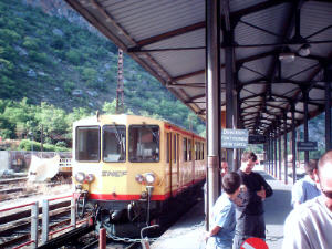
Yellow train
After a few hours you enter the ski village Pyrenees 2000, where I skied for the first time about 100 years ago.
From here you go on by road and you will meet a railway. This is what the yellow train uses. It is an old historical train that goes from La Tour de Carol to Villefranche. You can not miss it!
From here it is about half an hour to the station Cabanasse (near Mont Louis).
From the gite at Bouillouse to la Cabanasse takes about 4 hours.
This is walked in June 2006
From La Cabanasse (1507 meters) Mont Louis to Planes (1539 meters)
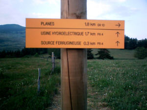
Planes
I have done the transport of the luggage of Hiroko, a Japanese/Australian woman from Perpignan to a gite just before Banyuls. From there I went by car to Arles sur Tech where I took the train and the bus to Mont Louis.
At half past 7 I go under the railway and walk to Planes which is about 3 kilometers. I take some hills and arrive in Planes where you can find several gites. I spend the night in gite d’etap l’Orri, a luxury and beautiful just renovated gite with a swimming pool. Owners are an Americain and a Spanish woman who are very friendly.
In Planes the GR10 and GR36 come together.
From Planes (1539 meters) to Mantet (1550 meters)
caranca
Around 8 am I start hiking after breakfast. Very soon you find a sign with Refuge del Ras de la Caranca, 6 hours. 2 hours later just before refuge de l’orry I take a brake. It is a nice stretch to walk. A little later at the refuge I meet Hiroko. She spent the night also in Planes only another gite. We talk a little and I go on.
Around 1pm I am at coll Mitja at 2367 meters. The refuge del ras de la Caranca is another hour walking and has very friendly prices, but is also pretty basic. No bathroom, showers or water in the refuge but very nice situated at a river…….
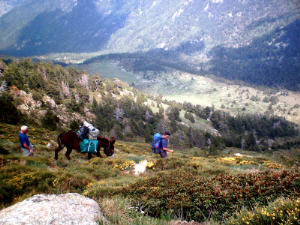
Around 2 pm after lunch I start walking again. Mantet is another 4 hours. You reach Mantet via coll del Pal at 2294 meters. Just an hour before Mantet I met 4 men with dunkeys. They are retired and are doing a cabin to cabin hike where the donkeys take their luggage. They look very satified. Around 6 pm I arrive in Mantet. First you walk next to the vegetable garden of the gite la Girade owned by a Belgium woman and a French man (French guide). It is very easy to talk Dutch.
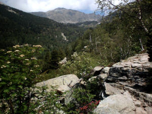
From Mantet (1550 meters) to Chalet de Cortalets (2150 meters)
Cortalet
Last night a lot of bikers arrived at the gite and in the morning I have breakfast with some of them. Around a quarter past 8 I leave and go to the Col de Mantet. I meet some other hikers and after half an hour I arrive at the Col at 1760 meters.
In Py there is also an auberge now and you van still use the gite of the community. In this gite you can spend the night (no half board) but yo can use the kitchen. You can also have your dinner in the auberge.
From the Col to Py is an easy walk and at noon I arrive at Coll de Jou at 1125 meters. Refuge de Marialles is another 2 hours walk and Pic de Canigou is another 6 hours. The pic is not on the official GR10 so I will not take it but of course it is possible to do. Around half past 1 I arrive at the refuge where I take a break. This refuge can be reached by car.
10 minutes later you find a sign with Chalet de Cortalets 6h10 just near a picnic table and water. Just another 6 hours…..
Around 8 I arrive the Chalet/refuge. It is a big complex with a simple room for 10-12 people and alo it is possible to take a room. It is also a restaurant. There are a lot of people and I can put on my tent just near the river.
From Chalet de Cortalet (2150 meters) to Arles sur Tech (232 meters)
Dunkey
After a breakfast with bread that I could buy at the refuge I start hiking again. Around 11 I see a Maison Forestiere at 1479 meters that looks pretty and can be used by hikers. I take a big break here. Around 12 I am at Col de la Cirere at 1731 meters. I see a sign with Arles sur Tech 3h45. A little later I pass a gite that is being renovated. I can drink a cup of coffee and go on. At 4 I arrive in Arles near the camping Riufere waar we celebrated the birthday of Marcel (with Frodo).
From Arles sur Tech (232 meters) to Las Illas (550 meters)
I thought that this stretch would be 9 hours, but a 15 minutes walking I saw a sign Las Illas 10 hours and 5 minutes!
And I needed that time.
After 4 hours walking you pass a gite d’etappe. Untill so far the GR10 markers are doing fine and you pass also some points where you can take water.
A few hours later you see some houses. According to my map you have to go on the road but the markers point you a different way. You follow Col de Puits de Neige. The patch stays marked ok and finally you arrive in Las Illas.
Here you can sleep in a gite or in the Hostel. Dogs are not allowed to sleep in the rooms of the hostel but they can sleep in a barn. The room and the food is ok.
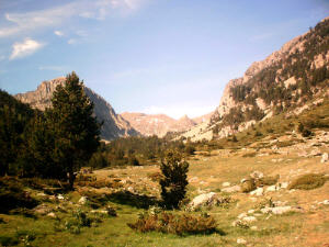
From Las Illas (550 meters) to Refuge de la Tagnarede (1045 meters)
View Ouillat
From Las Illas to Le Perthus is about 3.5 hours walking. The path is marked ok and just before Le Pertus you pass an old fort (de Bellegarde).
From here you descend via the road to Le Perthus. It is a crowded place ith a lot of shops ans restaurants because it is near Spain. You can buy cheap cigarettes and liquor and there are several accommodations to spend the night.
From Le Perthus to the refuge is a little 4 hours walking. After 2 hours you pass a gite / restaurant, which is closed on monday and tuesday.
You finally climb to Pic Neulos. From here it is a little descend to the source. From here it is 5 minutes to the refuge.
The refuge is a large cabin were 8-12 people can sleep without matresses, but with a fire place and a table and benches. We spent the night with 2 other hikers and 4 people (smoking and drinking).
The alternative for this refuge is the gite we just passed.
The stretch from Las Illas to the refuge takes about 7 hours, if you won’t get lost…
From Refuge de la Tagnarede (1045 meters) or the gite Ouillat to Banyuls sur Mer (14 meters)
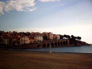
Banyuls
After a breakfast in the refuge we leave our friends and start hiking. From the refuge you can see the Mediterranean!
The path is marked pretty ok but it does not tell you where you are exactly. Coll des Gascons you follow for a long time but it does not tell you if you are there.
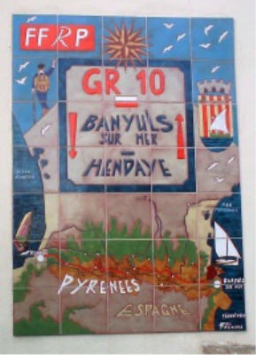
After 6 hours walking you arrive in Banyuls, the end of the GR10. In Banyuls you see a nice sign of the GR10. With a coke (or a beer) you can celebrate your victory! From Banyuls you can go by train to Perpignan and from there to La Tour de Carol or Narbonne, Toulouse, Parijs etc. Also from Perpignan there is a bus to Le Perthus.