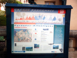
GR10 Description in the Pyrenees
The Atlantic Pyrenees from Hendaye to Arrens in 2018
 The French Pyrenees are about 900 km and consist of the Atlantic Pyrenees, the Pyrenees Centrales, the Ariege and the Pyrenees Orientales.
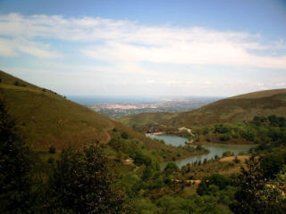
The Atlantic Pyrenees consist of the Pays Basque and the Bearn. The GR10 part here is about 260 kilometers and starts in Hendaye and ends in Arrens.
The GR10 part what goes through the Pyrenees Centrales (Hautes Pyrenees and Haut Garonne) starts in Arrens and ends in Fos. This part is about 220 kilometers.
The Ariege consists of the Bergtoppers domain and the GR10 starts in Fos and ends in Merens Les Vals. This part is about 225 kilometers.
The last part, the Pyrenees Orientales, ends towards the Mediterranean and that GR10 part is about 210 kilometers. You start in Merens les Vals and you end in Banyuls sur Mer.
Since 2007 we offer the whole year backup from Melles until Goulier. You must think of luggage transport combined with the reservation of your accommodations. We also offer the whole year (from june till october) 2 self lead GR10 stretches: from Melles to Seix and from Seix to Goulier.
We also offer luggage transport, reservation of your accommodation, deliver maps and a detailed description and we can take care for your lunches.
And we walk the part from Luchon to Merens every year to check if something changed (cabins open/closed, difficulties etc.)
From here a description of the GR10 stretches that I have done. I started at Hendaye and ended in Arrens. Of course any one can use the description but you can also contact Bergtoppers.
Pyrenees Atlantique
From Hendaye to Etsaut that I walked in Mai 2006
From Hendaye (10 meters) to the cabin at the 3 fontains (532 meterr)
I went to the tourist office to pick up a map of Hendaye because the GR10 is not marked very well. When you use this map it is a peace of cake to find the GR10 in Hendaye.
The official starting point of the GR10 is the casino in Hendaye. From there you leave Henday via some little streets for the beginning of your big GR10 adventure. In Hendaye also the HRP (Haut Route Pyrenees) starts, but this is maybe something for later?
Via some hills you follow the GR10. In Mai 2006 a part of the GR10 was blocked because of renovation so you had to take another road. Finally I could pick up the GR10 further on but it was a little difficult.
After 2.5 hours walking, in Briatou, you see a sign: Olhette 4 hours 15.
After another 2 hours you come at Col d’ibardin 317 meters, this is already your third col for today. If you want to do the whole GR10 than a lot of cols shall follow! At this col you also find a bar/restaurant and a shop.
From here it is another 2h15 to Olhette.
** The stretch from Hendaye to the gite in Olhette takes about 6 hours 30 **
In Olhette you will find a gite and also a sign with Sare 3h05. I walked another 2.5 hours to the cabin at the 3 fontaines. This cabin is very well situated and near by a river.
From 3 fontaines (532 meter) to Bidarry (70 meter)
 After an early breakfast (coffee, bread and cheese) I left from “Arrano Xola”, where I slept very good. After a few minutes I reach the Col des 3 Fontaines (563 meters). Here you find signs with Sare en Ainho (4h35).
10 minutes later you pass the railway. This is a touristic train that start in Sare and goes to the mountain La Rhune. In summer it can be very crowded.
After a while you reach Sare where you will find a lot of shops including a hotel and restaurant. Sare is known as one of the most beautiful places in the Pays Bask. There is a cash dispenser and you will meet the GR8 here. After a little walk you come to a place near the Spanish border with a Spanish restaurant. From here Ainho is another 1.5 hour. Here you will find a very good hotel and a tourist office and a post office.
** The stretch from the gite in Olhette to the hotel in Ainho takes about 6 hours 30 **
After Ainho, where you won’t find any shops, you follow the signs with Chapelle 2h20. On your way up you meet some white crosses. Finally you reach the chapel and a little further you find 3 crosses…..
Very impressive!
From the chapel to the Col des Veaux it is another 1.5 hours walking.
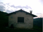
Before you reach this col you pass Ferme Esteben. There is no sign any more that this is a gite and it does not look very friendly but don’t let it stop you. The people are friendly and you can still spend the night (half board) for a reasonable price.
From the Col des Veaux (574 meter) to Bidarry it is another 3h30. So you have some time to go and in the end you have to go down steeply. Just for the village you go up according to the signs. And this is what you have to do otherwise you come down in the village. The village is spilt into 2 parts ; one part up with the church/gite/hotel/camping where you have to be.
When I finally was at the right place the gite was full so I had to spend a night in the hotel with a very nice shower.
** The stretch from the gite in Olhette to the gite in Bidarry takes about 6 hours **
From Bidarry (70 meters) to cabin “Urdantzia ko Lepoa Basaizea Elkartea” (869 meters)
After another early breakfast I start walking at half past 7. Very soon I find a sign with Baigorry 8 hours.
 You start pretty steep and very soon I am being passed by several locals. (of course with a little rucksack!).
Here it is some kind of a national sport to climb as soon as possible the hill and then go back to the village. I think that the GR10 is not marked very well here but (while a local is just saying the opposite) you can find it. Every time you walk further to the next hill on the cretes and sometimes you see the bottom below. But it is not scaring. I saw also a lot of vulgars.
After 5 hours walking I am at the Col de Buztanzelhay on 843 meters. From here it is another 2h15 to Baigorry. until so far I did not see any water!
2 hours later I arrive in Baigorry where I find a bus station a bar and a casino (shop) a Tourist office and a swimming pool. There is also a gite to spend the night.
** The stretch from the gite in Bidarry to the gite in Baigorry takes about 8 hours **
 From Baigorry it is another 6h15 to St.Jean Pied de Port. I go on for another 3.5 hours and reach a cabin which is not locked but the doors are closed. Excellent! I do not know if it is allowed to spend the night here but that is what I do. There is even water in the cabin.
From the cabin (869 meters) to the gite Kaskoletta (500 meters)
 I leave around half past 7 and reach the col after half an hour (1021 meters). St.Jean Pied de Port is another 2 hours walking. You walk a lot on the road and around half past ten I reach St.Jean Pied de Port . The first shop I see is a Lidl where I buy a cola and some batteries for the camera, from there you come in the center.
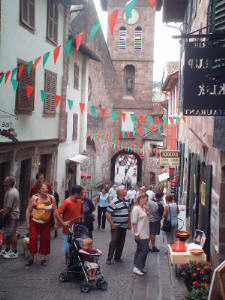
This is a very nice place and it is worth a visit. There are a lot of shops, hotels and it is crowded with tourists. You also meet people that are doing the GR65, or the Santiago de Compastella. You also find here refuges that are specially for the Santiago the Compastella pilgrims. So it is a nice place for a long stop or a restday.
** The stretch from the gite in Baigorry to the hotel in St.Jean Pied de Port takes about 6 hours **
Outside the village you find a sign, Esterencuby 4 hours, where I arrive at 15h00. 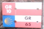 You find here several accommodations but no shops. I take a rest and go on at half past three. I meet a sign with Col d’Irau (4 hours). I walk until 17h00 and spend the night in gite d’etap Kaskoleta, where I am the only guest. There are some very good facilities like a television, a magnetron, a freezer, cooking geer etc. and I slept very well……..
** The stretch from the hotel in St.Jean Pied de Port to the gite Kaskoletta takes about 6 hours **
From the gite Kaskoletta (500 meters) to Gite Iraty (1284 meters)
Today I left a little later because I will meet my wife and children (and the dog) at 13h00 at Chalet Pedro. They come to support me.
After half an hour walking I see a sign with Col d’Irau 1h45 and Col Bagarguiak 6h15. When I am at the col I decide to wait a little because of the rain. A spanish car is doing the same. Fortunately I did this because lightning hits the groud 20 meters in front of me. It rains cats and dogs a 5 minutes later the sun is shining so I go further. This was a very special experience.
From the Col d’Irau to Chalet Pedro is another 2h30. I reach Chalet Pedro at half past 12. There a 2 rooms with 2 double beds with wc and douche outside, while you have to cook in the garage. When the weather is fine it is excellent for a hiker, for a family probably not. I decide to wait for the rest. So we go to Chalet Iraty and spend the night there. It is a very nice place with a restaurant and shop nearby. From Chalet Pedro to Chalet Iraty is another 2 hours walking.
** The stretch from the gite Kaskoletta to the gite Iraty takes about 7 hours **
From the gite Iraty to the Gite in Logibar (380 meters)
After a late breakfast with my wife and children I started walking again. Frodo, our dog, did not like it at all that he could not come with me but the next time…….
I left at half past ten and at the col you find signs with Logibar 5 hours. Here I also saw a big GR10 sign with the places and the gites from the neighborhood. After 6 hours walking I reached the gite/auberge in Logibar, where you can buy also maps.
Todays’ stretch looks a bit on the GR10 stretches which will come further on.
** The stretch from the gite Iraty to the gite in Logibar takes about 6 hours **
From Logibar (380 meters) to Saint Engrace (625 meters)
Today I decide to start late so I leave the gite at 9h00 after breakfast. After the bridge you go to the left and follow the GR10 to Saint Engrace and Gorges d’holzarte. After a wooden bridge there is a parking place where you follow the Passerelle d’holzarte. Very soon you see an impressive bridge where I could not take any pictures because of my camera was full. Also the canyon is very impressive so next time…….
If you are at the Col Anhoueha on 1383 meters you must pay attention. You see the GR10 going up because of the wooden pieces. This is the GR10 I followed. There is also a variant but I did not find enough markers.
The last piece to St. Engrace is via the road. The gite is close nearby a church where you can take a look it is worth the trouble! You can also sleep in your tent in the garden of the gite, but the gite is not expensive at all.
** The stretch from the gite in Logibar to the gite in St. Engrace takes about 8 hours **
From Saint Engrace (625 meters) to Plateau de Lhers (997 meters)
Today it is another long day for me, so after another early breakfast I start walking. I have some small talk with a french guy who lives in Switzerland. He tells me that the ski station where I go to today will not give any snow problems………
Very soon I see a sign with La Pierre St.Martin 4h10. Here is the ski station. I go on via a little stony track. After a while you enter a narrow canyon. This is the border between the Pays Bask and the Bearn.
One and a half hour before La Pierre St. Martin you ‘ ll find a guardian at a water sunk, a stony statue. Unfortunately the camera is still full!
** The stretch from the gite in St. Engrace to the refuge takes about 5 hours **
At noon I reach La pierre. Unfortunately the refuge Jeandel on 1670 meters is closed so i take a break. From here it was a little difficult to find the GR10 because of the snow but I managed. However it is too early to do this stretch in Mai.
At the ski station everything is closed also the cash dispensers. You see a lot of Red and White markers but from the refuge you go down a little and further up.
I leave the ski station at 13h00 after my dejeuner with bread, cheese and meet. The track stays rocky a real GR10 track in the Pyrenees. 2 hours later you come to a heavy passage (Pas de l’Osque at 1922 meters). until so far it was steep but it can be worse!! I took the passage at the left side but it is probably better to do it at the right side.
This is also a famous passage on the GR10, so stay cool and if the GR10 impresses you then you are not the first.
One hour later I pass a cabin that looks very good. Space to cook a table and chairs. At 17H00 I am at the refuge . Unfortunately everything is closed, there is not stay for in the winter. 1 hour later I am in Lescun.
** The stretch from the refuge to the gite in Lescun takes about 5 hours **
Lescun is a very nice place with a bar a post office and a refuge that was closed. From here it is another 2 hours to Plateau the Lhers where I shall sleep in my tent. The hike is very easy and the plateau is very beautiful next to a river with a nice view. There a some people with a camper van and a family is eating here. Tonight is my last hiking night and tomorrow I go by bus and by train to Oloron Hendaye to pickup my car and go back to the Ariege.
From Plateau de Lhers (997 meters) to Borce/Etsaut (588 meters)
This last night I slept very well and I leave after breakfast (bread, cheese and coffee) at half past 7. One and half hour later I reach Col de Barranq at 1601 meters. A pretty simple climb so after breakfast. From here it is another 2 hours to Borce and 2h20 to Etsaut.
If you want to spend the night in the gite in Borce you go to the bar. Here you also find a little shop and you can go to the internet via WiFi and a satellite. You pay 5 euros an hours or 1 euro 25 for 15 minutes (so are the French: a price is a price). The whole valley uses WiFi and the satellite. Borce and Etsaut are next to each other but being separated by the Route National.
The bus leaves at Etsaut where you find some other gites and a hotel. There is also a nice restaurant where you can by IGN maps. There is a nice atmosphere in the villages.
At 13h00 I leave Etsaut by bus and I arrive via Hendaye in the Ariege late in the evening because of a delay of the train from Pau to Hendaye.
** The stretch from the gite in Lescun to the gite in Borce takes about 6 hours **
From Etsaut to Arrens I have done in September 2006
From Etsaut (588 meters) to the cabin (1560 meters)
mature
I went by car to Luchon and from there by bus/train/bus to Etsaut. At 16h00 I start hiking.
I had some problems to find the right direction but finally I found the GR10 going to the Chemin de la Mature. This track is cut out in the rocks in the 18th century, to reach the woods above Aspe and Ossau.
The first part is on the road but after some time you come to a parking place where you leave the road and from there you start climbing. Around half past 7 I see the cabin which is just in the National Park. I am curious if I am going to see a lot of animals in this Park.
The stretch from Etsaut to the National Park takes about 3 hours.
From the national park (1560 meters) to the cabin de Cezy (1643 meters)
corniche
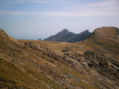
I start hiking at half past 8. The scenery is very beautiful and 2 hours later you reach Lac d’Ayous. First you pass the col at 2185! meters. At the lake you will find the Refuge where you can spend the night. I also met some other people here.
Probably they drove from Gabas to the lake Bious-Artigues and from there they start hiking. The hike from the lake to Gabas is about 2 hours. Around 13h00 I arrive in Gabas and lunch at the refuge.
** The stretch from the gite in Borce to the refuge in Gabas takes about 9 hours **
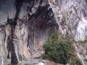
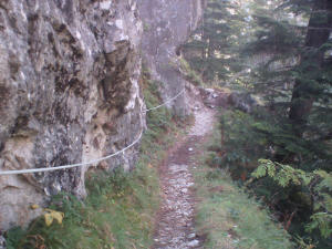
Just a little outside Gabas you find a sign with Gourette 8 hours 30. After one hour hiking you come in the famous Cornich Alhas. Is is an impressive path that is cut out in the rocks. On the right side you find a cable and on the left sight you can look down…… You walk here around 20 minutes.
At 17h00 it starts raining but I decide to go on until the cabin de Cezy. I reach this cabin one hour later. It is pretty low but it is possible to spend the night here. The shepard tells me where I can find water. Later that evening it stops raining so I hope that the weather will be ok tomorrow. From the cabin you can also see the Petit Train d’Artouste that is going on the opposit mountain. This is also a touristic attraction.
The stretch from the National Park to the cabin de Cezy takes about 9 hours.
From cabin de Cezy (1560 meters) to Arrens Marsous (877 meters)
 After a reasonable night and a good breakfast I start hiking at 8. The weather looks good! After 3 hours I reach Hourquette d’Arre at 2465 meters. This is not the highest point of the GR10 but it is even pretty high. until so far I have just seen marmots.
After a little piece of descending I am ascending? I do not see any Red and White marks any more but only yellow. I do a very steep part and reach a ski elevator. Fortunately here is a nice view at Gourette but it is not GR10. A bit before this I had to go the right and continue descending. But there are no marks here!
In Gourette I take a little break. The refuge de Pyrena is closed but the CAF refuge had to be open but for the moment no boy in the house. Maybe I am to early. The hotel in the neighborhood gives me a brochure that will not survive the rest of the week because of the rain.
Around half past 2 I start hiking again and after 90 minutes I reach the col de Tortes at 1799 meters. Here you meet the D918 (a road) and you follow this road. After about 3 km. you reach a sign that indicates the border between the Pyrenees Altlantiques and the Haut Pyerenees.
Around half past 7 I enter Arrens Marsous. The GR10 is marked pretty good. I spend the night in the gite Camelat because there would be a sauna. But the saune is “en panne”. The next morning after a little talk with the owner, a french guy from Normandie.
** The stretch from Gourette to the gite in Arrens takes about 5 hours **
The stretch from the cabin de Cezy to Arrens Marsous takes about 11 hours.